SENTIER DE LA ROCHE DU BLAIREAU

surceneux
User
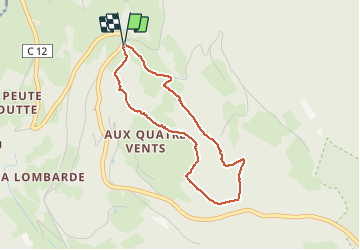

Length
3.2 km

Max alt
812 m

Uphill gradient
136 m
Km-Effort
5.1 km

Min alt
670 m

Downhill gradient
140 m
Boucle
Yes
Creation date :
2021-03-31 13:49:33.521
Updated on :
2021-03-31 18:25:41.441
57m
Difficulty : Very easy

FREE GPS app for hiking
 SityTrail
IGN / Geographical institutes
SityTrail Plus
The world is yours!
About
Trail Walking of 3.2 km to be discovered at Grand Est, Vosges, Le Tholy. This trail is proposed by surceneux.
Description
DEPART ECOLE BOUVACOTE
SUIVRE LE CERCLE BLEU
Positioning
Country:
France
Region :
Grand Est
Department/Province :
Vosges
Municipality :
Le Tholy
Location:
Unknown
Start:(Dec)
Start:(UTM)
332586 ; 5326861 (32U) N.
Comments